Going down the Yukon: last leg up to Dawson city,
400 km in canoë and back… home.
- last of 5 articles on this subject, first published in French, translated by Joanna Bremond.
Once arrived in Carmacks, we installed our camp near the bridge. Since Whitehorse, this is the only section where the two shores of the river are linked… which just shows how rare communications are between east and west. It’s also the only real town before Dawson City, our destination.
- credits © Romain Dartigues -
It must be remembered that the Canadian province of Yukon is a huge territory, almost as large as Spain, with fewer than 34,000 inhabitants (half as many as the inhabitants of Cannes) and if the provincial capital, Whitehorse, contains three quarters of the population, Carmacks (named after one of the first gold hunters of Yukon) only has 450 inhabitants and registered housing for 221 in spite of the fact that it’s the administrative centre for the natives of the region.
We found ourselves near the town centre, a euphemism in view of the fact that Carmacks has more bears than inhabitants: “Three bears for each of the residents in this town, 35 km square”, as the forest warden told us. It was he who helped us get rid of the 12 huge canisters, the foundation of our wooden raft, telling us that he’d find good use for them. He also gave us permission to let go the logs, which would run aground downstream, for, we had to face it, there would be no hope of keeping to our programme if we didn’t get rid of the raft. We discovered later that if we’d reached Dawson City with the raft we’d have been able to sell it to the locals who would have used it for firewood. There the climate isn’t warm enough to enable the forest to prosper, and felling is strictly controlled in order to protect the resources. We therefore dismantled our raft.
The visit of the town was done in a trice. In the library, which doubled up as a youth centre, with a small hall for sports and festivities, many newspaper cuttings were pinned up on the walls, along with warnings about health and security (alcohol, drugs, precautions to be taken when on the river, and concerning wild animals).
– General-store and Service station, Carmacks -
We discovered that in this region, supposedly isolated from the temptations of larger towns, alcohol consumption and the use of hard drugs were on the rise, especially among adults. We stocked up in a sort of “postcard” general store a kind of repair centre with its own petrol station with pasta, rice, vegetables, fruit, ham, tea and sugar. Another “must” that we greatly appreciated were hot showers our first since Whitehorse they were expensive, too short, the “flow” was not negotiable and what was more the water smelt of sulphur but we appreciated them all the same… and we then visited the local laundry. As clean as new pins, we allowed ourselves a beer and a meal of fresh meat in a tavern, where the barman’s eyes were “in bean grease” a Quebec expression meaning “groggy”… he separated two female Amerindians who were tearing each other’s hair out… “They’re always at it”, he said, without seeming unduly concerned.
- Banks of Yukon, naturally eroded…
Once we’d recharged our digital cameras we left the next morning in our two canœs to get on with the trip downstream, about 400 km. We calculated that we’d have to do 70 km per day to ensure that our Parisian girl could catch her return flight.
- A long river, often calm…
We had been among the last expeditions to leave Whitehorse, and in Carmacks we were certainly the last. The air and water temperatures were going down rapidly during the day it was hardly more than 10C and at night the temperature often went below zero, and as for the water, it was near 4C at Dawson. The days were getting shorter too as we went north, towards the top of our map which pointed towards the arctic and the icy wastes… At the end of each afternoon the sun went down behind the mountains, which made it colder.
The season was coming to an end, bars and canœ hirers were closing, seasonal workers were packing their bags, the water level was going down by as much as 20 centimetres in some places, which meant we had to push the canœs several times, as they were touching the bottom… and now we were facing, with a certain amount of anxiety and an increase of adrenaline, the test of the Five Finger Rapids. Carried by the current, however, we went through without a problem, and extremely impressed by the grandiose setting visitors are very struck by the swirls and eddies, and the rocky islets which point their “fingers” skywards.
But we had no time to lose, we had to paddle hard in order to maintain our daily kilometres, as simply letting ourselves go down with the current wasn’t enough there was no question of landing to explore, even if we had dreamed of stopping to smell, look, and listen… We had to paddle for seven hours a day pretty tough for the more or less beginners that we still were. What with the sun and the water our hands had started to look like leather. Paradoxically, if it wasn’t for the cold and the accumulation of tiredness, this part of the trip down river was less stressful than the first part. On the raft, we had to be constantly on watch for obstacles, cope with those we couldn’t avoid, struggle to find a place for the night, then set up the camp.
- Fort Selkirk: welcome!
The next day, 19th September, we arrived at Fort Selkirk after 6 pm. This was our only stop of importance. We spent a whole day and two nights there, which didn’t suit those of us who had timetables to consider and who made their opinions known to the guide, who didn’t seem particularly concerned. We visited this site, fitted out as a memorial, above all for tourists.
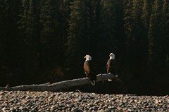
- White-headed bald eagles, often confused with Golden eagles -
Several moose and bald eagles reassured us about the continued existence of their species. Our contacts with the owners of a small camp site lower down the river were disappointing… this was a local family which didn’t seem happy with its job, suffering from boredom, indifference to visitors and to the surrounding natural world.
- Fort Selkirk cabins -
The reorganisation of this little village was a success, and was enlightening. We stopped to take a series of photos for the promotion of the expedition for our guide’s sponsors. Built higher up river in 1848, and rebuilt in its present situation in 1852 to house a community of angelised amerindians, it was finally abandoned in 1950. It appeared to be still in fairly good condition, with two churches the most recent of which had exceptionally good acoustics for a wooden building and the school, with benches almost intact, and the stove… All the buildings were log cabins, or built with planks for the most luxurious cabins, the roofs of some of which had been taken over by vegetation. There was no means of access except by river, and of course there was no question of running water or electricity nor agriculture, the winter being too long and severe ‐ survival only being possible with hunting, gathering, and the sale of what could be trapped to the famous Hudson’s Bay Company.
- Migrating swans -
At nightfall, migrating swans whose relations had been passing overhead daily since our departure, decided to camp for the night on the island next to Fort Selkirk. During the whole night, several hundred of these birds took turns to inform the area of their presence their “songs” becoming louder as dawn approached then they took off in successive waves of several hundred individuals as dawn finally broke. The last difficulty before arriving at our destination was a tributary of the great river, which pushed us towards the shore. We had to call upon all our remaining strength to extricate ourselves.
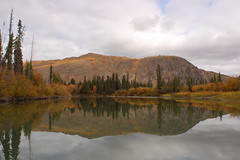
- Misty morning…
Night was falling, at last, when we finally got to Dawson City, but the day wasn’t over, for we still had to pull the canœs out of the water, make sure they were safe, and empty and clean them, before we could return them to the hirer and find somewhere to spend the night. The amount of equipment still on our hands was a problem. The guide wanted to keep the lot, which weighed about 200 kilos, some of which was particularly bulky, such as the prospectors’ tent. The trip had been longer and therefore more expensive that we had foreseen, so we were broke, particularly as the return journey as announced by the guide to be about 20 dollars turned out to be a mystery. It would cost 200$ per person for a bus, more than 300$ for a plane ticket (without counting the excess baggage), or to hitch‐hike with all our belongings. The problem had to be solved, time was getting short, and we still had to find somewhere to sleep.
- Camera Obscura -
At the last minute we squatted the “Camera Obscura”, a cabin of about 2m50 by 2m, (described by Aristotle and by Léonard da Vinci, it was the ancestor of a photographer’s dark room), slightly out of the town centre we squashed in with all our baggage for a short and uncomfortable night. Our New Zealander, not satisfied with the vague explanations and the general indecision of the guide, had the good idea of going off to town to try to find a solution, and in the local paper she discovered in the small ads a well timed proposition by a local guide to go to Whitehorse in her minibus for 100$, and for five passengers she had agreed to drop the price to 80$ each.
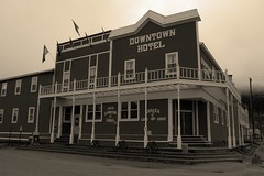
- Downtown Hotel - Dawson City - with its wooden sidewalks - a city which had up to 30.000 inhabitants during the Gold Rush was the capital of Yukon province until 1952. There now remain only 1 250 inhabitants !
The last morning I got up early to take photos of some of the picturesque houses, (some of which, built on the permafrost, looked as if they were about to collapse), remains of the glorious days of the gold rush. There was no sign of Calamity Jane in the deserted streets made of hard packed earth and I felt disappointed not to be able to stay longer to explore the town and the region, and I promised myself that I’d be back one day.
Our owner/driver didn’t expect to see so much luggage, and didn’t much appreciate it, but we finally got going, and did the 500 km, soothed by the tales she told. It was obvious how much she loved her job, and did it with all her heart. She seemed to know every aspect of the flora, the fauna, the history and the politics. We only came across a few other vehicles on the road it was obvious that the season was coming to an end.
When we got to Whitehorse we were keen to recuperate the belongings that we had left in the care of a Frenchman. Married to a girl from Quebec, he was in charge of a small ski resort and obviously enjoyed his life. It was soon time to say goodbye, and for me this moment turned out to be very unexpected, and totally unsatisfactory. The guide, for whom I had made a certain number of purchases, didn’t want to reimburse me, and on the other hand I felt most unwilling to let him have all the photos I’d taken with my own camera. In any case a professional photographer always takes his equipment back to his studio before handing the results over to his sponsor, and this is what I wanted to do. However the guide insisted, and even threatened me physically. The other members of the group obviously didn’t feel concerned, and didn’t intervene; even though I had the impression that they too felt that the guide’s credibility had disintegrated throughout the trip. In the end, however, I gave in, feeling bitter. Our goodbyes were brief and cut short.
I decided to return to Montreal by Greyhound bus via Edmonton, Winnipeg, Thunder Bay, Wawa (!), Sudbury and Ottawa. Four days in buses, no more comfortable than a charter plane, but cheap. I had time to consider whether the glass was half full or half empty… I would need time to decide. The weather too was gloomy it rained during the whole of the 5 500 km of a never ending trip…
- from a story told by Romain Dartigues - translated by Joanna Bremond -


